It was autumn 2021 and I was looking for an adventure. Something big. On a bike, more than likely. For the first time after many years of parenting and doing a full-time job, I had an opportunity to spread my wings. All the years of dreaming could finally be made real. But what?
It didn’t help that we were in the throes of a global pandemic. International travel was complicated at best. A domestic adventure, perhaps, was the right choice. Exotic could wait.
The idea hit me unexpectedly when I started looking at maps of Britain. Ordnance Survey maps, of course – the 1:50,000 Landranger series. I have loved them all my life but never before noticed the numbering system. I could cycle across all 204 of them, in numerically ascending order.
About 7,000 miles, I reckoned, which would be a nicely challenging amount for the six best cycling months of 2022. Better yet, it seemed no one had ever done this before. It was the perfect adventure: to cycle all of Britain and go everywhere.
Across the pounding sea rose the rocks and lighthouse of Muckle Flugga. It felt like the edge of the world
In the pink
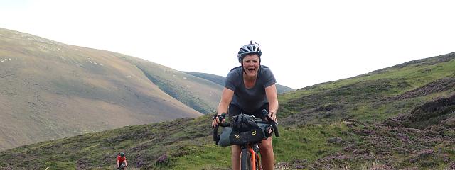
And so, on 9 May 2022, I found myself high up on the wild cliffs of Hermaness on the island of Unst. I was at the very top of Shetland – and map number one – sitting on the grass alongside my wife, Jenni, and a great many puffins. It doesn’t get much better than that.
Across the pounding sea rose the jagged rocks of Muckle Flugga, with its impossible-looking lighthouse, Britain’s most northerly. It felt like the edge of the world.
We spent the next week traversing the remote and mostly treeless Nordic archipelagos of Shetland and Orkney, ticking off the first seven Landrangers, battered daily by fierce wind. We rode ferries and visited archaeological sites of great antiquity. I saw no Scottish flags here. People feel a cultural pull to the north, reflected in the place names and local traditions.
It felt, in many ways, very far from my home on map 110 in the Derbyshire hills. It would take me until late September to reach home by bike, exactly half the Landranger series away.
On the small ferry from Papay (on map 5 Orkney Northern Isles) to the Orcadian capital of Kirkwall on Mainland, we met an elderly man who was born and raised on the nearby island of Westray. As his car was winched aboard, he told us about the queen’s visit there in 1960 on the royal yacht.
The biggest change to island life, he recalled, was when the fields on Westray were fenced and you could no longer simply walk in a straight line anywhere you liked. We said we had just come from Shetland. “I’ve never been there,” he said.
Map 8 lay inconveniently on the north of the Isle of Lewis in the Outer Hebrides. It required me to make the first of many circuitous journeys across Scotland to reach the starting point of a west-to-east traverse of the country. This initial horizontal pass, the first of 26 in my journey through Britain, would take me across the empty north coast of Scotland to map 12. But not before a couple of ferry journeys and many extra miles.
It was a pattern to be repeated throughout the many islands that adorn the west coast of Scotland, all the way south to Arran on map 69. My rules allowed me to use any transport available to get back from east to west after each crossing of the country. But up here the options were always limited and extra ‘unofficial’ cycling was often needed. It was a fiddly business, constrained by ferry timetables and locations.
It made for slow progress and regular overnight stops in the main transport hubs of Inverness, Glasgow and Edinburgh, before pushing out on early trains to increasingly familiar ferry ports like Ullapool, Mallaig and Oban. I experienced all weathers in each of these places but l learned to love them.
They were my gateway to different worlds – sparsely populated outlying islands of empty roads, flower-filled machair, barren rocky hills and white sand beaches. Car drivers waved at you to say hello.
Surveying Britain
May gave way to June, and I crisscrossed Scotland several more times. While headlines screamed of scorching weather further south, up here it was cool and, most significantly for me, very windy. I had been a regular visitor to the Isle of Skye, lying as it does at a crossroads of several maps and ferries.
It was here that I experienced the power of gale force winds in combination with rain, blinding me completely and forcing me to stop and seek shelter where there was little to be found. But conditions always improved and rewarded me with incredible, brooding mountain views made more dramatic by the ever-changing skies.
Too many people know about Skye. It was busy and not my favourite place to cycle. Yet all around it, for mile after mile, I feasted on the lesser known but equally stunning landscapes of the west of Scotland.
The wind kept the midges away and it mostly stayed dry. I often enjoyed exceptional weather without it ever getting uncomfortable. The landscape was always green for me as I slowly travelled south.
The islands of Harris and Mull were incredible places to ride a bike. I had days that I would not have altered for the world, when I was out cycling after dinner, late in the long summer evenings, all alone except for the mountains and the cuckoos, or red deer, or sea eagles.
But in truth just about everywhere I went, in every corner of Britain, I found calm and beauty. There is no better way to drink it all in than from a bicycle.
At times I was astonished how quiet the roads were. Maybe everyone travels from north to south? It often felt that way. Certainly, it seemed as if most people swarm together and occupy the same busy places and roads, leaving large empty spaces in between, where cycling was a true pleasure.
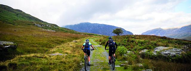
I can happily recommend several of my routes across little-visited parts of Britain as worthy contenders for official coast-to-coast status. Whole regions, like Galloway, the Scottish Borders, Northumberland and the Isle of Man were a cyclist’s delight. Mid-Wales was perhaps my biggest surprise. It had somehow eluded me until now. I crossed it three times and loved every minute.
In all of these sparsely peopled areas, I followed an important rule: never pass an open café (or pub/food shack/whatever was available). There were many days when, had I not been strict about this, I might not have eaten for hours – especially, for some reason, on a Monday.
Happily, by staying true to my rule, I benefited in the form of many pots of Earl Grey tea, large lattes, energy-filled cakes, and a good many bowls of soup (especially in Scotland, where I developed a love of Cullen skink). If the day was going well, I might allow myself a quiet pint of local beer before the end was reached. I always seemed to go faster after that! Bottom line: the long-distance adventure cyclist needs regular fuel.
Map legend
Route planning was a daily challenge. I generally knew which two dots I was trying to join together. That might be because I was staying with someone I knew or had met – a highlight of many evenings on my trip – or it might be the best place I could find to stay at an affordable price. But I often struggled to know the best way to move east, crossing the boundary into the next map, without everything laid out in front of me.
Some days I managed it alone. Other times I had to call in help. For the trickiest bits, especially in the more populated parts of England, Jenni would text me long lists of village names that I would join together in small pieces as the day went by. It worked, though. The quiet lanes and villages of Northamptonshire could be as lovely as the Cotswolds, and without the tourists.
As time wore on, I was rarely more than a few days ahead with my plans, often less than that.
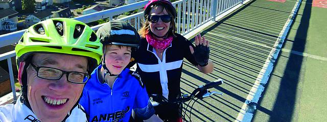
After a family holiday in early September, I picked up my journey again on map 95, the Isle of Man, and rode almost without interruption until the end of October. By then I had finished all of Wales, and had a magnificent day being guided through London by Penny, a local cyclist whom I first met on a train outside Inverness!
I was eating through the miles like never before but also fighting a losing battle against the diminishing daylight. I reached Cornwall for the first time at Bude (map 190). Then, on my first ride after the clocks changed, so did the weather. October had been incredible.
When my back brake failed on map 193 on a dark and very wet Halloween, my good fortune seemed to have ended. My most important rule was that it must be fun. For the last two hours that day, it wasn’t. I went home unsure if I would finish that year.
Then early November brought the most unseasonal week of warm, summer-like weather. I hand picked the weather windows and managed to ride all of the last two coast-to-coasts in sunshine. I shot across the south coast, stopping off for a wonderful visit at Ordnance Survey HQ in Southampton along the way (map 196).
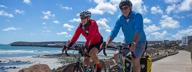
After Eastboune & Hastings (map 199) I had just five more to go. I finished, as I started, in the company of my wife – one of many people who chose to ride with me for a part of my route, long or short. Like the unexpected overnight stays with long-lost family and friends, these days were made special because of the company and conversations.
People, it seemed, liked to be a small part of my big idea. I am eternally grateful for the hospitality I was shown by so many. It made the trip for me.


")
")
")