Darllen yn Gymraeg
If you have a question that isn’t answered here, please get in touch and we can add it to the list.
What does the name Traws Eryri mean, and how should I say it?
Traws Eryri translates in English as ‘Trans Snowdonia’. In 2022, the National Park Authority decided to drop the names Snowdonia and Snowdon and use only the Welsh names Eryri and Yr Wyddfa, to celebrate the area’s culture and encourage people visiting to learn more about the Welsh language.
Traws Eryri is a Welsh route, so it has a Welsh name. If you’re wondering how to pronounce it: ‘Traws’ rhymes with ‘mouse’; Eryri is ‘eh-ruh-ree’.
Back to top
How do I get there and back, and can I leave my car for a few days?
By train
As it’s a linear route, the train is probably your easiest option so you don't have to worry about getting back to a car. There are stations at Machynlleth and Conwy (and also Barmouth and Blaenau Ffestiniog along the route - although bear in mind the viaduct to Barmouth is currently closed for works). Llandudno Junction station is a 10-minute ride from Conwy and has more trains running, so might be more convenient.
The connections running across Wales aren’t super frequent so the journey can take a while depending where you’re coming from, but on the plus side they are very scenic routes.
It's wise to make a bike reservation when you book your ticket, as most Transport for Wales trains on these routes only have two bike spaces per train. If you're then using connecting Avanti West Coast services, reservations are compulsory. See our guide to taking your bike on a train for more information on how to book a bike space. For the cheapest tickets, you'll need to book in advance for a specific time, so make sure you allow enough time to finish your ride!
By car and train
If you don't leave near a station and need to drive to a start point, one recommended option is to drive to Shrewsbury and then use the train to get to Machynlleth and then back from Conwy. It's quicker and easier than taking trains all the way round from Conwy back to Machynlleth.
By car
If you’re travelling by car, Maengwyn Street pay and display car park in Machynlleth lets you buy a multi-day ticket, and is good value. There are also a few car parks in Conwy where you can park for more than 24 hours.
Steve's Taxi has been recommended for transporting you and your bike back to the start. Contact on 07958 545751 or stevestaxicab26@hotmail.com
There are several MTB guiding companies such as Mountain Bike Wales and Bikepacking Wales who may also be able to help transport you and your bikes from end to end if you contact them.
Back to top
How long does it take to ride the route?
The trail is 196km / 122 miles long, with 4424m of ascent.
Bear in mind the terrain and steep gradients can make progress slower than expected, so plan your daily distance accordingly – we recommend three to four days if you want to enjoy it rather than put the pressure on.
Back to top
Which kind of bike is best?
We'd recommend a hardtail mountain bike for riding Traws Eryri. The wide-ranging gearing is the most handy part here, allowing you to winch up the many steep inclines that you’ll face along the route.
Secondly, wider tyres will allow you to take on the rougher descents (and a few climbs) with much more confidence. A bit of suspension will make things more comfortable for you over multiple days on the bike, as well as aiding grip. Using a mountain bike also opens up the chance to take in some of the purpose-built mountain bike trails at Dyfi Forest, Coed y Brenin, Penmachno and Gwydir Forest.
It's true that a fair portion of the route is on tarmac or gravel forest tracks, so you might be tempted to use a gravel bike for less drag on the smoother surfaces. While you technically can ride Traws Eryri on a gravel bike, you’re likely to be undergeared – especially if loaded up with bikepacking bags and camping kit. Some of the descents are rocky and loose, so wider tyres are much better. If riding a gravel bike, you’ll probably have to walk a few sections which are a little more technical, though thankfully they’re quite short.
We don't recommend using road, touring or hybrid bikes with limited gearing and/or narrow tyres, as it will make life pretty difficult.
An electric bike will make the climbs easier, but plan ahead for recharging points as Eryri will drain your battery faster than most landscapes.
Back to top
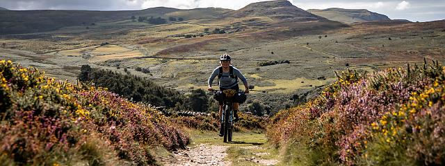
How difficult is it? What’s the terrain like?
The main challenge of Traws Eryri is the gradients. Most of the time, your wheels will either be pointed up or down. Much of the route uses gravel forestry tracks and some quiet roads, but some sections are quite rough and rocky, which adds a level of technical difficulty to a few of the descents, particularly in wet conditions.
Make sure you have a bike and gear that you feel confident with, and there is always the option to get off and push if you don’t feel comfortable. Consider how much you carry, as a loaded bike will handle very differently on the descents.
The route connects with trail centres at Dyfi Forest, Coed y Brenin, Penmachno and Gwydir Forest, which provides options to incorporate a few MTB trails into your ride.
Most of the trails we use have a stony base, so you won’t get bogged down whatever the weather.
There is a short section of hike-a-bike towards the end of the route (at Ty’n-y-ffrith near Conwy Mountain) on a restricted byway which is quite boggy and difficult to follow. Future route improvements will hopefully allow use of the better-surfaced footpath and bridge slightly to the south, but that would currently involve lifting your bike over a stile.
More more info, have a read of Katherine Moore's thoughts on How hard is Traws Eryri?
Back to top
Is there information about accommodation and facilities along the way?
At the back of the route guide, there is a table showing the facilities in each town or village close to the route, to help you plan your trip.
Back to top
Are there guided or supported trips available?
Mountain Bike Wales and Bikepacking Wales are both planning to run supported trips.
Back to top
Can I ride it in either direction?
The route has been planned with south to north in mind, for gradual climbs and fun descents and because it’s always quite satisfying to finish at the coast. That said, you can of course also ride it the other way from Conwy to Machynlleth.
Back to top
Is the route signposted?
Traws Eryri isn’t signposted, and though it follows a few short sections of other promoted routes, for most of it you’ll need to pay attention to your navigation. You can download the gpx file on the main route page, and the route is fully mapped at the back of the printed route guide.
Back to top